Absorb the Snæfellsnes Peninsula.
| Private Tour |
Experience the energy of the mystical "Iceland in miniature" Snæfellsnes peninsula with the comfort of a private tour and make the most of your day by choosing from various bookable activities to add.
-
![]()
Available
All year round, every day
-
![]()
Duration
Approx. 12-14hrs, depending on time spent at stops and activity duration
-
![]()
Pick-up
From your hotel/accommodation within the Reykjavik Capital Area
-
![]()
Activities
Extra bookable activities can be chosen during check-out


Description.
The weather can be unpredictable in Iceland, so during winter, you may expect us to occasionally alter the tour itinerary if weather/road conditions are unfavorable.
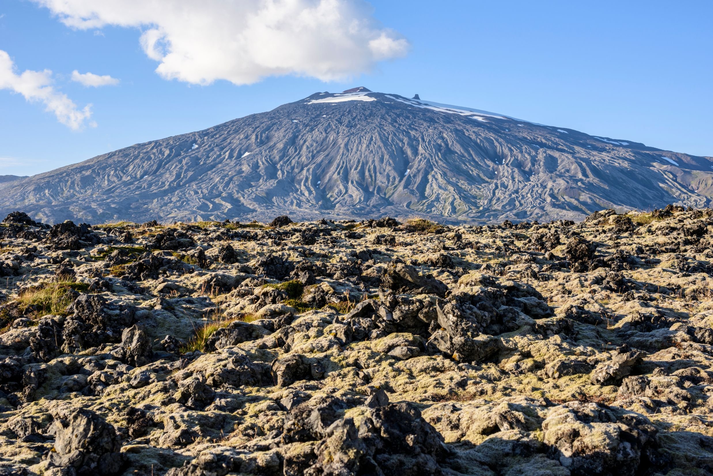
Snæfellsnes is a peninsula that possesses a great diversity of what Iceland has to offer. Its unique landscapes of rugged moss-grown lava fields, charming little fishing villages by the coastline, and wealth of remains and history dating back to the period of settlement and the formation of Iceland, makes for a whole day of "Iceland in miniature". The Snæfellsnes National Park is the first national park in Iceland to stretch from the top of a mountain with its boundaries reaching out into the ocean. At the far end of the Snæfellsnes National Park stands the renowned glacier Snæfellsjökull, believed to be one of the seven energy centers or chakras of the world due to the great powers and energy that many people sense when in its presence. It plays a big role in Jules Verne's science fiction Journey to the Center of the Earth published in 1864, and a movie of the same name in 2008 starring Brendan Fraser and the Icelandic actress Anita Briem.
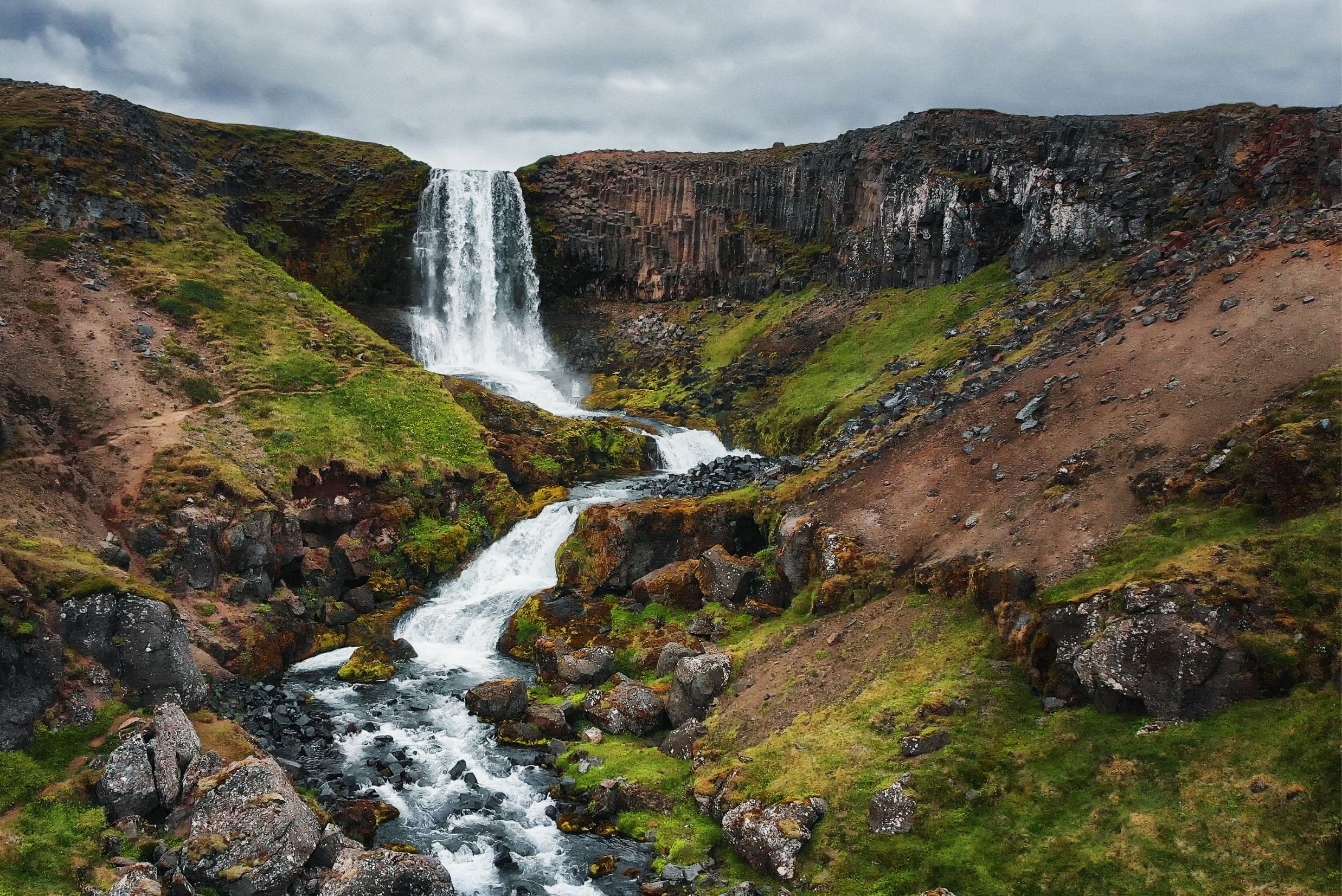
Getting to the Snæfellsnes peninsula, we will head from the Reykjavik Capital Area to the Hvalfjörður fjord and drive through the Hvalfjarðargöng underground road tunnel, the first underwater tunnel to be built in Iceland and among the longest underwater road tunnels in the world. Before we get to Snæfellsnes we'll drive over Borgarfjarðarbrú bridge, the second-longest bridge in Iceland, and make a stop in the town of Borgarnes for refreshments and restrooms, and to stretch our legs. After driving past a lot of beautiful farmsteads we turn on to Vatnaleið, a mountain pass between the north and south coasts of the Snæfellsnes peninsula, and stop at a rest stop by the Fossá river. From there you will have a vast view over the Selvallavatn lake surrounded by the 4,000-year-old rugged Berserkjahraun lava field which was created in an eruption of a row of four scoria craters. A short walk from the rest stop takes you to the two-ledged Selvallafoss waterfall which is also known as Sheep's Waterfall due to sheep sometimes resting on a ledge behind it. We drive a bit further and stop by one of the scoria craters that created Berserkjahraun, the high and wide Gráakúla. It derives its name from the grey moss covering this otherwise beautifully red-colored crater. Now we make another turn and drive through the lava fields of Berserkjahraun to reach Grundarfjörður, the environmentally-conscious fishing town which lies by the roots of the very picturesque Kirkjufell mountain. If you're a Game of Thrones fan, you will immediately recognize this mountain as Arrowhead Mountain in seasons 6 and 7. Along with the small waterfall Kirkjufellsfoss, this pair makes for the main attraction and landmark of Grundarfjörður and one of the most photographed locations in Iceland. Next, we drive by the shore to the old market town Ólafsvík which used to be one of the largest trading posts in Iceland. We highly recommend having your lunch at our favorite restaurant here which offers a range of delicious courses with freshly caught fish from the harbor (and for those who are vegan, they also have a variety of great vegan dishes on their menu). After a short drive from Ólafsvík, we stop by a parking lot for a short walk to a viewing platform to admire the beautiful waterfall Svöðufoss, falling gracefully off a basalt-columned cliff.
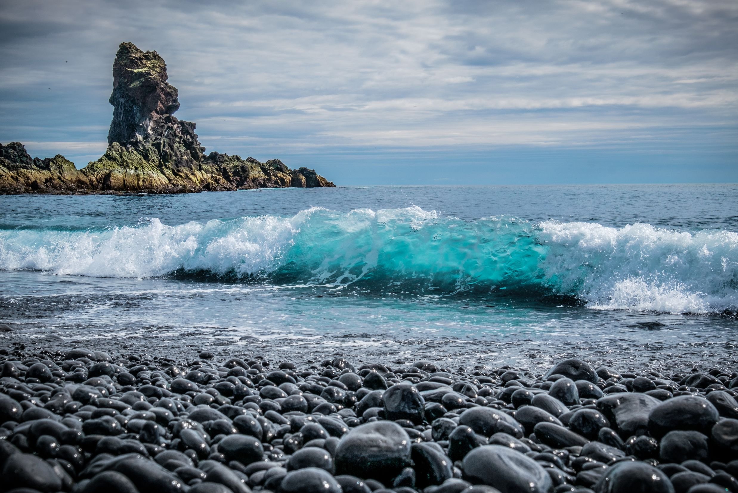
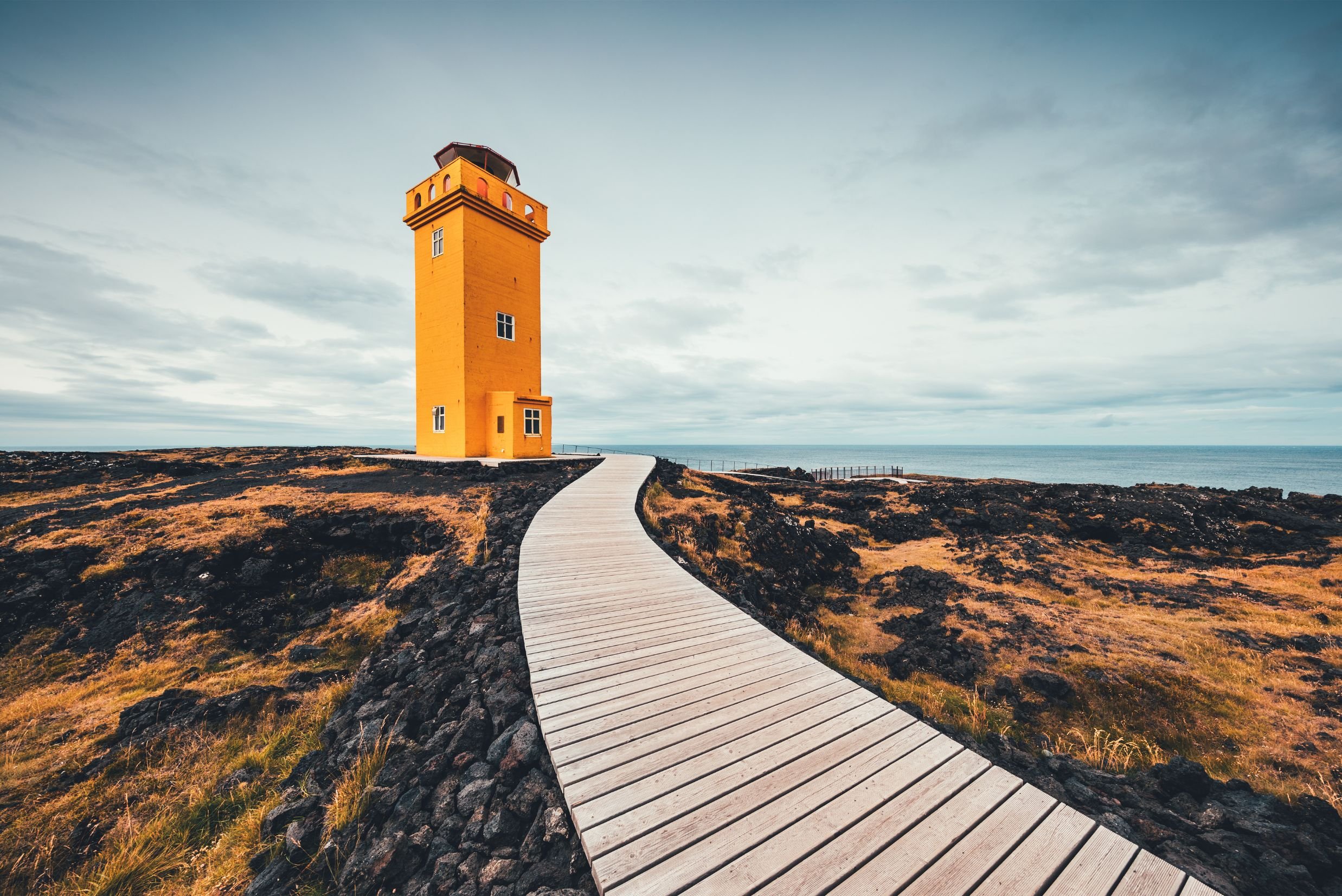
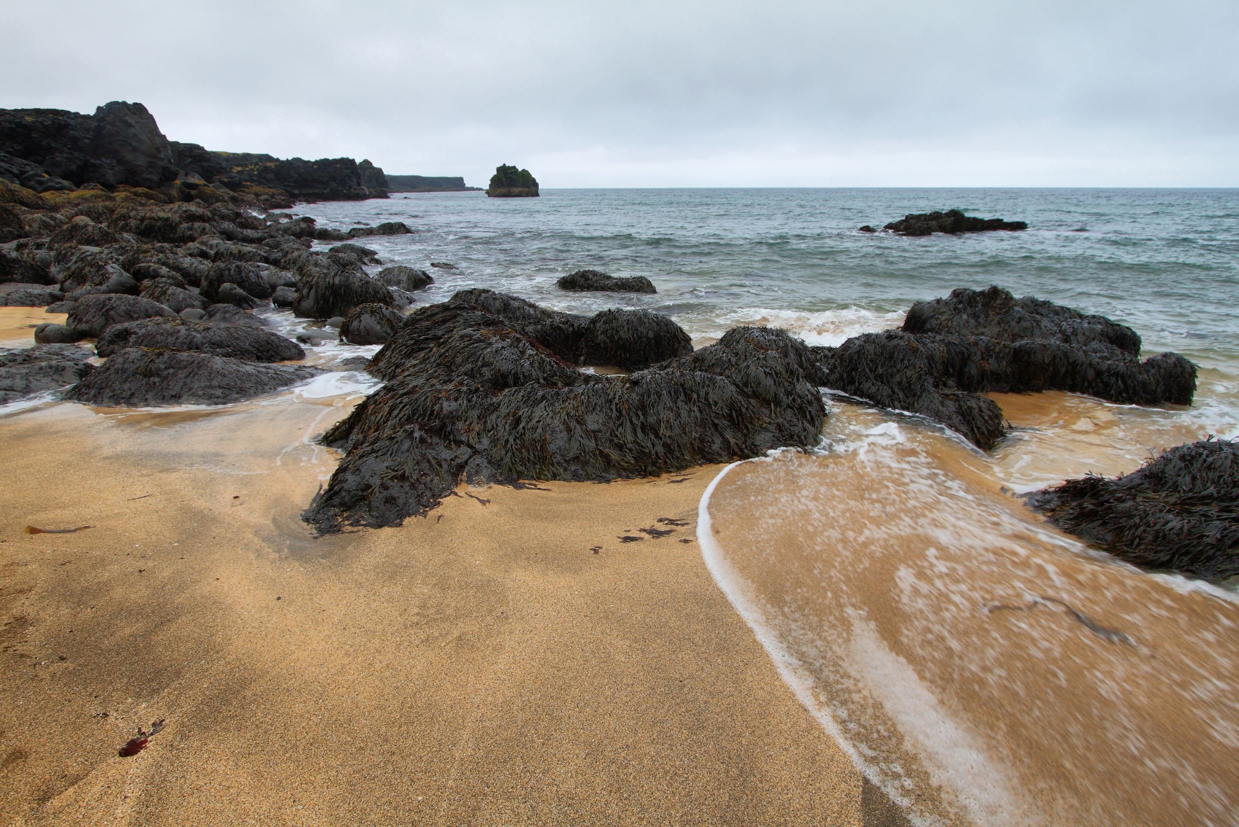
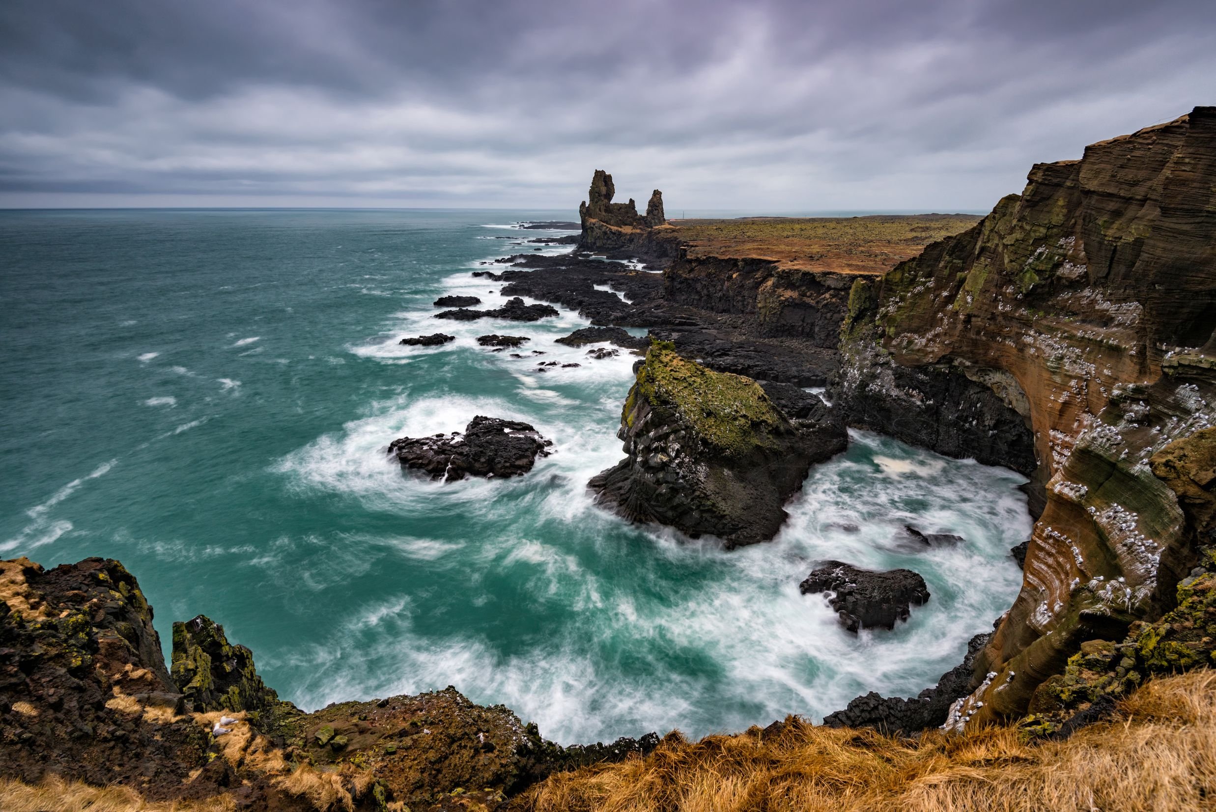
Now we reach the far end of Snæfellsnes and stop by the beautiful beach Skarðsvík which is different from the black beaches of Iceland. This secluded beach has golden sand surrounded by deep black fractured basalt columns and a bright aquamarine-colored ocean. Further west we stop by the first lighthouse of the day on the cape Öndverðarnes. For over 700 years since the 13th century, this was an old fishing station with a lot of fishermen's huts and a chapel on-site. Old relics and ruins from that time can be found in the area, but now the small orange-colored lighthouse Öndverðarnesviti stands on its westernmost point. South of it stands another orange lighthouse with two names; Svörtuloftaviti when seen from the sea and Skálasnagaviti on land. The coastline between these lighthouses is called Svörtuloft or Black Ceilings, deriving from the steep pitch-black lava cliffs that a lot of ships have crashed on and shattered in extreme weather. We now drive alongside the main landmark of the Snæfellsnes peninsula - the glacier cap Snæfellsjökull. Dominating the area, this mysterious glacier is said to keep great secrets. It is believed that the half-man half-troll and protector of Snæfellsnes Bárður Snæfellsás lives in it, disappeared after a tragedic family accident. Snæfellsjökull is an active volcano that last erupted 1,8000 years ago, so on top of this 1,446 m high glacier sits a 200 m deep crater bowl. We continue our way to the black pebble beach of Djúpalónssandur. A walking path through a lava field takes you to this magnificent beach with remains from the 1948 shipwreck of the British fishing trawler Epine GY7 scattered around. Both the pebbles of this beach and the shipwreck are protected, so they are to be kept there and not removed. Please admire this scenic area carefully and mind the strong waves coming ashore. Another shore close by gives you an amazing view of various cliff formations from an observation deck, all the to the abandoned farming area Malarrif where the 24 m high lighthouse Malarrifsviti stands. By the observation deck is the palagonite headland Svalþúfa with a cliff called Þúfubjarg beneath which is home to various nesting sea birds. Standing just out of the shore are the two rock pinnacles Lóndrangar, believed to be the elves' church and their library.
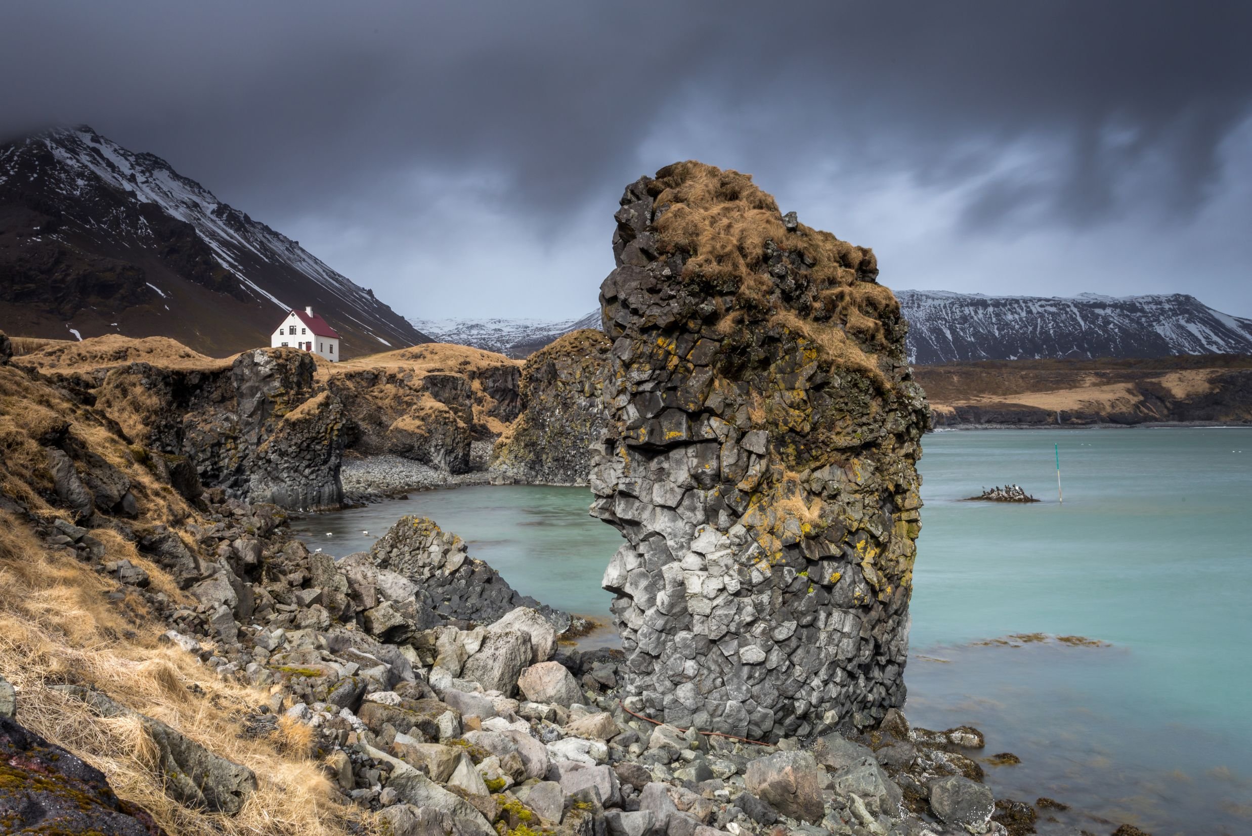
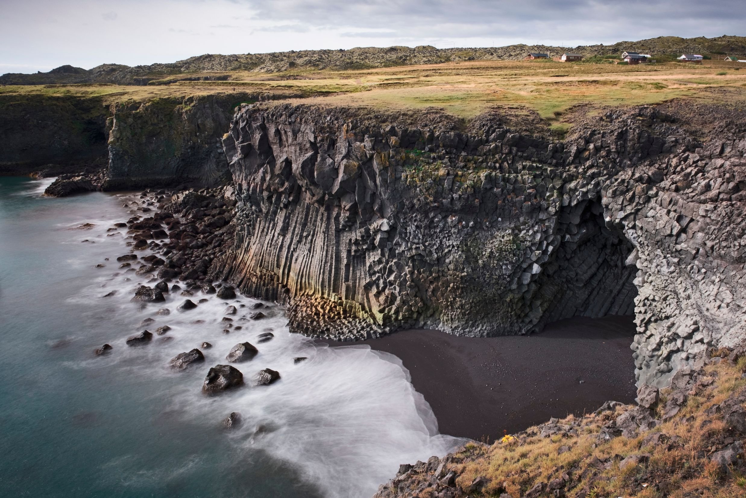
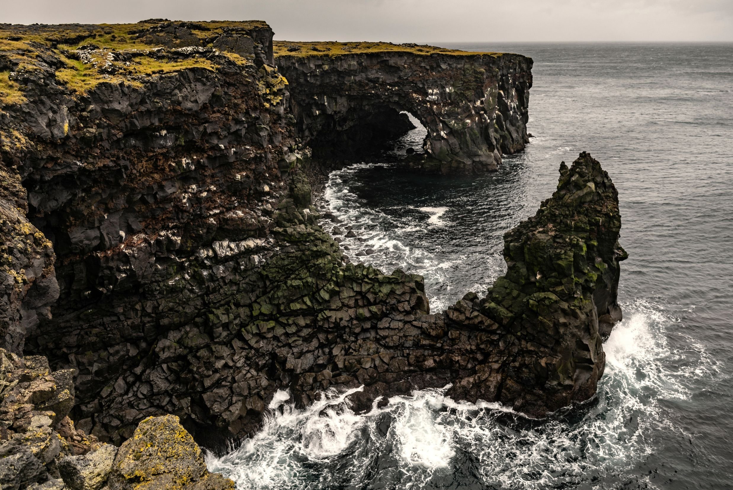
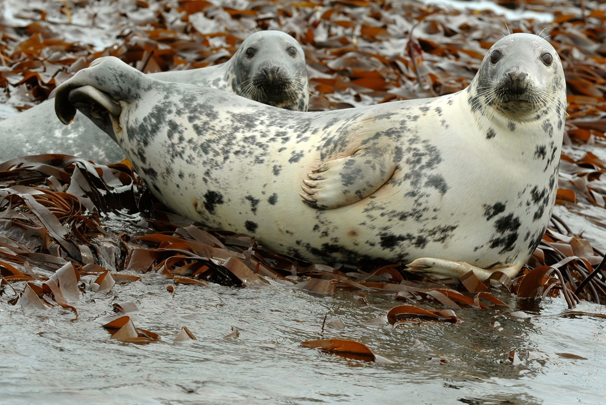
Next are the twin villages of Hellnar and Arnarstapi. Hellnar was a large old fishing station dating back to 1560 but now only a few people live there. A cozy little café by the beach Hellnafjara is popular for the great views it offers from its patio and down by the beach is the remarkable cave Baðstofa inside the protruding boulder Valasnös. Its magical uniqueness lies in the coloration inside formed by the tides and different lightning hitting the scales of rocks inside. Arnarstapi is a small fishing village with strange rock formations along its coastline and cliffs filled with nesting sea birds. First, you're greeted by the huge statue of Bárður Snæfellsás, the aforementioned protector of Snæfellsnes. Then a walking trail takes you along the coastline for admiring various lava and basalt formations. The rock arch Gatklettur extends from the cliffs with a big hole through, and further along, are three holes in the ground with the ocean coming in and basalt cliffed walls with sea birds nesting on some days the strong ocean waves splash up into the air from these ravines. Nearing the end of this tour, we drive through farmlands by lava fields, and one of these farms was the home of a notorious killer. Axlar-Björn was the first serial killer in Iceland AND is still the only one. He lived on the farm Öxl in the 16th century, where he would kill travelers passing by with an axe. Hiding their bodies in the cowshed, killed 9 people and kept their belongings until one traveler managed to escape. That led to the arrest of Björn who was sentenced to death. Before he was beheaded, his limbs were crushed with a sledgehammer and his body was cut down and put up on poles, and then his body parts were dug in three graves, to prevent him from returning to haunt the living, with cairns on top. One of these cairns still stands in a lava field by Hellnar and is declared protected. After we've passed Öxl we turn to the very small village of Búðir by the edge of the pitch-black Búðahraun lava field. One of the most photographed churches in Iceland is the black wooden Búðakirkja church with its white window and door frames and a stonewall around its graveyard. It's a replica of the former church and the only reminder left of this former vibrant fishing village. Further down is a green-yellowish beach of olivine sand, which is very rare in the world. We make our way to our last stop which is the golden sand beach Ytri-Tunga. It has a large seal colony and is very popular for seal watching, especially over summer. Two seal species, the harbor seal and the grey seal reside here peacefully in harmony. Seals used to be vital for the survival of Icelanders, but now it is prohibited to hunt these beautiful creatures in Icelandic territory.
Select Your Date.
Or contact us here for a tailored experience. Every tour takes you to the highlights of its area - yet there are so many other spectacular locations on the way to explore.
FULL REFUND IF CANCELLED UP TO 48 HOURS PRIOR TO YOUR DEPARTURE
Highlights.
-
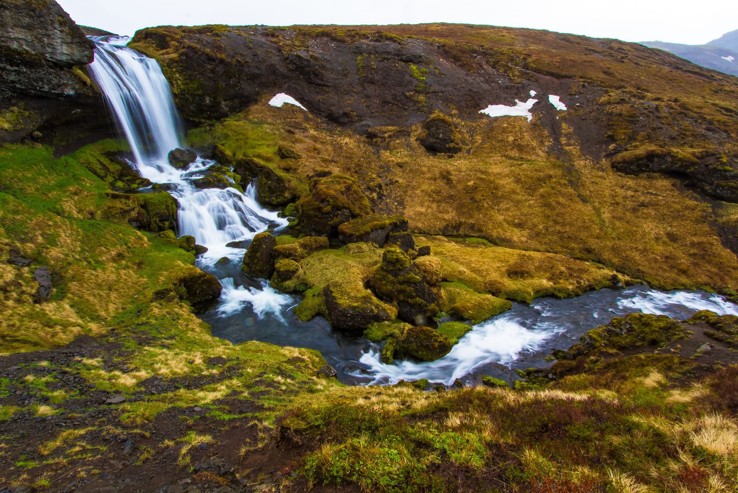
Vatnaleið is a mountain pass between the north and south coasts of the Snæfellsnes peninsula. It first opened in 2001, superseding the gravel road over the Kerlingaskarð pass. A rest stop by the river Fossá on this route has tables and chairs made from basalt rocks which were found during the construction of Vatnaleið. From there you have a vast view over the lake Selvallavatn and the surrounding lava field and mountain rows. A short walk up the Fossá river takes you to a two-ledged waterfall called Selvallafoss - also known as Sheep's Waterfall due to sheep sometimes resting on a ledge behind it. Further down this route is the 80 m (262 ft) high and 211 m (629 ft) wide scoria crater Gráakúla (mistakenly called Grákúla by some) which formed over 4,000 years ago. Being red, it is also covered with grey moss which gives its name (Gráakúla = e. Grey Bump). It is the second-largest crater in a row of four scoria craters that erupted over 4,000 years ago, with lava flowing in the NW direction creating the rugged Berkserkjahraun Aa lava field. The eruption of Grákúla created the Selvallavatn lake situated just south of the crater.
-
The town of Grundarfjörður has a population of a little under 900 people. It is one of the five communities of Snæfellsnes that in 2020 received a Platinum Certification by EarthCheck for environmental destination standards, confirming the Snæfellsnes region is an environmentally conscious community. Hovering over this fishing town is the 463 m (1,519 ft) mountain Kirkjufell (e. Church Mountain) known by fans of Game of Thrones as the Arrowhead Mountain in seasons 6 and 7, making it the main attraction and landmark of Grundarfjörður. Kirkjufell has been referred to as the most beautiful mountain in Iceland and is believed to be the most photographed mountain of them all.
Kirkjufell gives its name to the small Kirkjufellsfoss waterfall, which is often photographed as the foreground of Kirkjufell. It runs down the river Kirkjufellsá, creating three waterfalls all bearing the same name.
-
The little fishing village Ólafsvík is an old market town with a population of about 1,000 people. It was one of the larger trading posts of the 17th and 18th centuries in Iceland, being a commercial vessel between Denmark and Iceland, and was the first town in Iceland to receive commercial rights from the Kingdom of Denmark. In the town center stands an old warehouse constructed in 1844, which now serves as a museum and an information center. Called Pakkhúsið, it is among the few last standing business premises built in the 19th century and is a monument representing the town's past and history. We highly recommend making a stop for lunch at our favorite restaurant in Ólafsvík to try their delicious fish courses with freshly caught fish (they also have great vegan options).
A short drive out of Ólafsvík is the beautiful 10 m (33 ft) high Svöðufoss waterfall, falling off a basalt columned cliff. From the parking lot is a short walk to a resting area with a viewing platform to admire Svöðufoss.
-
Skarðsvík bay has a beautiful secluded golden sand beach surrounded by deep black fractured basalt columns, and the depth combined with the bright clean ocean makes it aquamarine-colored. Icelanders are more used to black sand beaches all around Iceland, so this beach makes for a change. Though the waves are not as strong and forceful as the ones by the Reynisfjara black sand beach on the South Coast, we still advise to not go too close to the waterline. A wooden path from the parking lot makes a short walk to the golden Skarðsvík beach.
In 1962 a heathen burial mound, believed to be from the late 10th century, was found shortly above the tideline. It was of a young male around the age of 14 and in his grave were his sword, a spearhead, and other grave goods. His remains were taken to the National Museum of Iceland for preservation, but an information sign is on-site at the northern end of the beach where the burial mound was discovered.
-
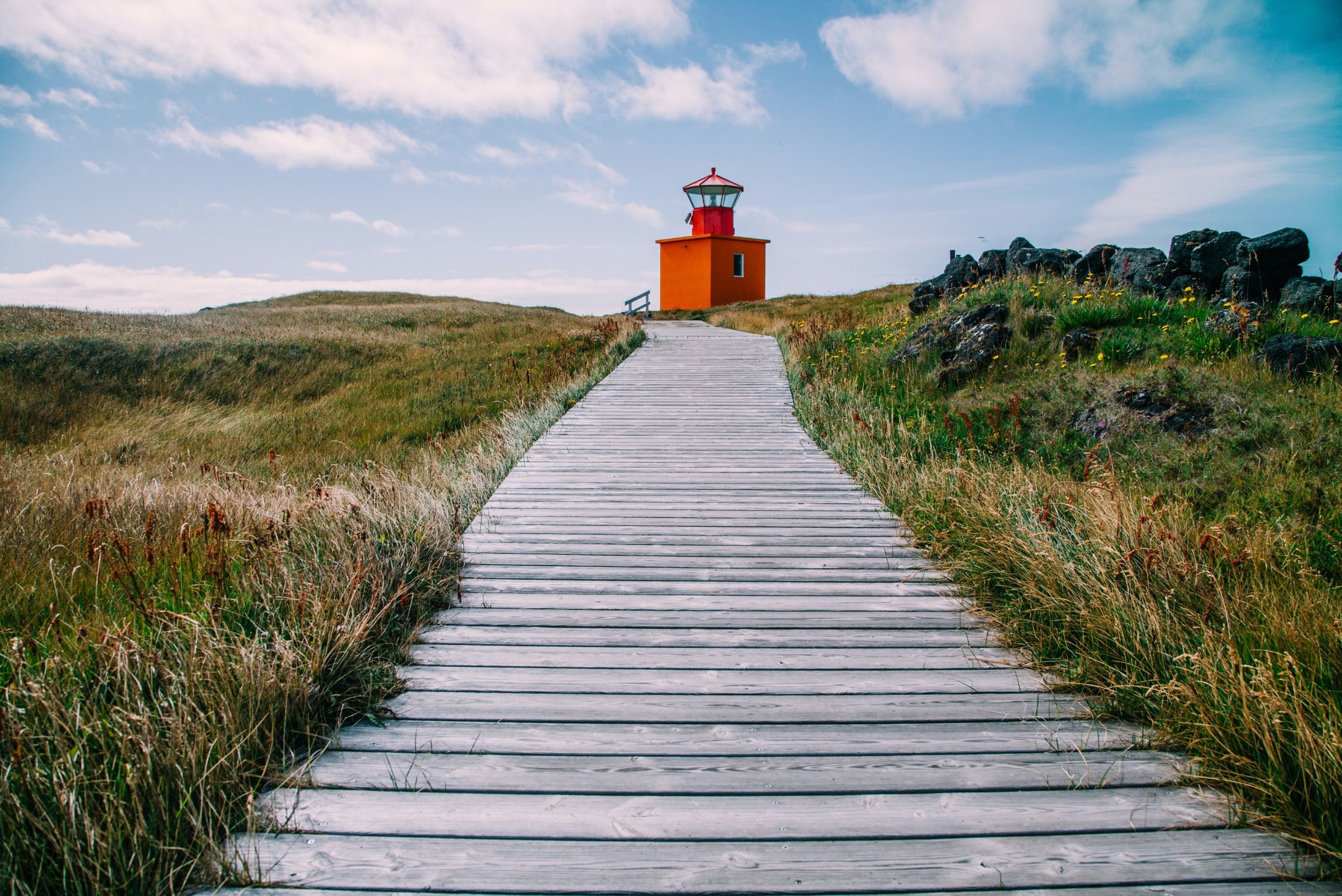
Öndverðarnes cape is the westernmost point of the Snæfellsnes peninsula which used to be an old fishing station from the 13th century into the 20th, with a chapel on-site and a lot of huts for the fishermen. There are a lot of old relics and ruins from ancient times and a deep partly covered stone well called Fálki (e. Falcon - mistakenly called Faxi by some) which can be entered by 18 steps of stone leading down. Fálki used to be the only waterhole in the area it was believed to contain three sources of water; one with freshwater, another with mineral water, and the third with saltwater. The small and orange-colored Öndverðarnesviti standing 5 m (16 ft) tall, was built in 1973 but before was another lighthouse built in 1909 which was the first lighthouse on the Snæfellsnes peninsula.
South of the Öndverðarnes lighthouse is another orange lighthouse built in 1939 by a cliff that used to have a stone bridge attached to the sea rock Skálasnagi, creating an arch before that bridge collapsed in 1973. What is unique about this 12 m (39 ft) high lighthouse is it bears two names; Svörtuloftaviti when you are out at sea, and Skálasnagaviti on land. Another lighthouse used to stand there, built in 1914, but it collapsed after the ocean waves had eroded the cliff. The rugged cliffside along the coastline between these two lighthouses is called Svörtuloft (e. Black Ceilings). The pitch-black lava cliffs are very steep and sharp and a lot of ships and boats have shattered to pieces when crashing these cliffs in extreme weather, leaving no survivors. The last shipwreck happened in 2001, leaving one survivor of four.
-
A short walk through a lava field down Nautastígur (e. Bulls' Path) takes you to the black beach Djúpalónssandur (e. Sand of Djúpalón). It's not a beach of sand but black smooth pebbles referred to as Djúpalónsperlur (e. Pearls of Djúpalón). These pebbles are protected so you are only to admire them and not take any away with you. Behind Nautastígur are do small loons called Djúpalón (e. Deep Lagoon) and Neðra-Lón (e. Lower Lagoon), which the beach derives its name from. By them are four lifting stones in different sizes called Aflraunasteinar (e. Test of Strenght Stones), used to measure the strength of fishermen who wanted to earn their spot on fishing boats. These lifting stones are: Amlóði 23 kg / 51 lbs (e. Weakling), Hálfdrættingur 54 kg / 119 lbs (e. Half a Man), Hálfsterkur 100 kg / 220 lbs (e. Half Strong), Fullsterkur 154 kg / 339 lbs (e. Fully Strong). If a fisherman could lift Hálfdrættingur, he was accepted on board.
Scattered around the beach are iron remains from the shipwreck Epine GY7, a British fishing trawler that wrecked in a severe storm east of the creek Dritvík in 1948. Only five men of the 19 men on board were saved. In memory of these brave English fishermen, these remains are kept on the beach and are not to be removed.
Further down the beach is a reddish lava rock called Söngklettur (e. Singing Rock), said to be an elves' church. Alongside the beach next to the cliffs is a lava rock called Kerling (e. Old Lady), said to have been a female troll carrying a bundle of fish on her back when turning into a rock when she got caught by sunlight. Please admire this area carefully and mind the waves, since a "sneaker wave" might snatch you if you stand too close and pull you out.
-
Two rock pinnacles stand tall just out of the shore called Lóndrangar (e. Lagoon's Pillars), 61 m (200 ft) and 75 m (264 ft) high. One of the pinnacles is believed to be an elves' church and the other to be their library. Due to the cliffs by the shore being so dangerous, an observation platform was constructed by Þúfubjarg and Svalþúfa for a view of Lóndrangar in distance. Þúfubjarg is a cliff that is home to various sea birds nesting, standing beneath the palagonite headland Svalþúfa. It is forbidden to mow the grass on Svalþúfa as it is believed to be inhabited by elves.
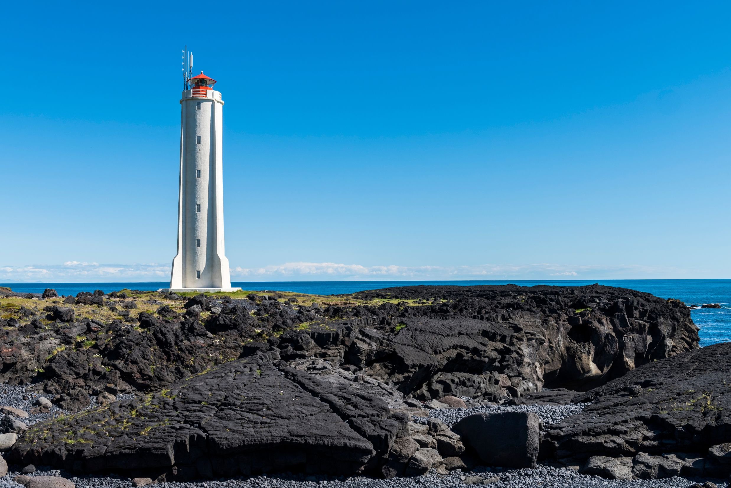
From the observation platform, you see over to the reef Malarrif where the 24 m (74 ft) high lighthouse Malarrifsviti stands tall. Built in 1946, it is a white cylindrical tower with a red lantern house on top. For centuries, Malarrif was a fishery until 1900 and then a farm till 1997 which now is abandoned.
-
The fishing villages Hellnar and Arnarstapi are commonly referred to as twin villages.
Hellnar was among the largest fishing stations on the Snæfellsnes peninsula, dating back to 1560. Having about 200 residents living there in 1703, with 38 buildings functioning as farms and lodgings and structures related to the fishery, times have changed since then. Fewer people live there now, with a hotel and a little café operated there. The café is by Hellnafjara (e. Shore of Hellnar) and is popular for the location and view it offers from its patio over beautiful rock formations by the sea. Locals often walk a 2.5 km (1.55 mi) route by the coast over Hellnahraun (e. Lava Field of Hellnar) to Arnarstapi, starting from this little café in Hellnar. Behind the café is a statue of the Virgin Mary by a holy spring called Maríulind (e. Spring of Mary), formerly called Gvendarbrunnur (e. Spring of Guðmundur) in reference to the bishop Guðmundur Arason nicknamed hinn góði (e. the good). He is believed to have consecrated the spring in the 13th century, giving it healing powers. In front of the café by the shore is the protruding boulder Valasnös with an opening and a cave called Baðstofa (e. Sitting Room), very unique for the coloration inside that forms due to the tides and different lighting and its walls being made of schist rocks which is a type of rocks that look like flakes or scales. Schists were sometimes used as tiles on the roofs of turf houses in some parts of Iceland. Close by is the abandoned farm Laugarbrekka, which used to be a church estate till the church was moved to Hellnar in 1883. The current standing church Hellnakirkja in Hellnar was built in 1946 instead of the former turf church. Laugarbrekka is the birthplace of Guðríður Þorbjarnardóttir, born in AD 980, who was an Icelandic explorer. She was called Guðríður víðförla, meaning the widely traveled. At the age of 20, she moved with her father to Greenland to accompany Eiríkur rauði (Eirik the Red), the father of Leifur Eiríksson (Leif the Lucky). Guðríður married Þorfinnur Karlsefni, and together, they led an expedition to Vínland, where she gave birth to their son Snorri Þorfinnsson, making him the first European being born in the Americas. This pre-Columbian Norse exploration by the Vikings of the mainland of North America is mentioned in the Icelandic Sagas and the Vinland Sagas.
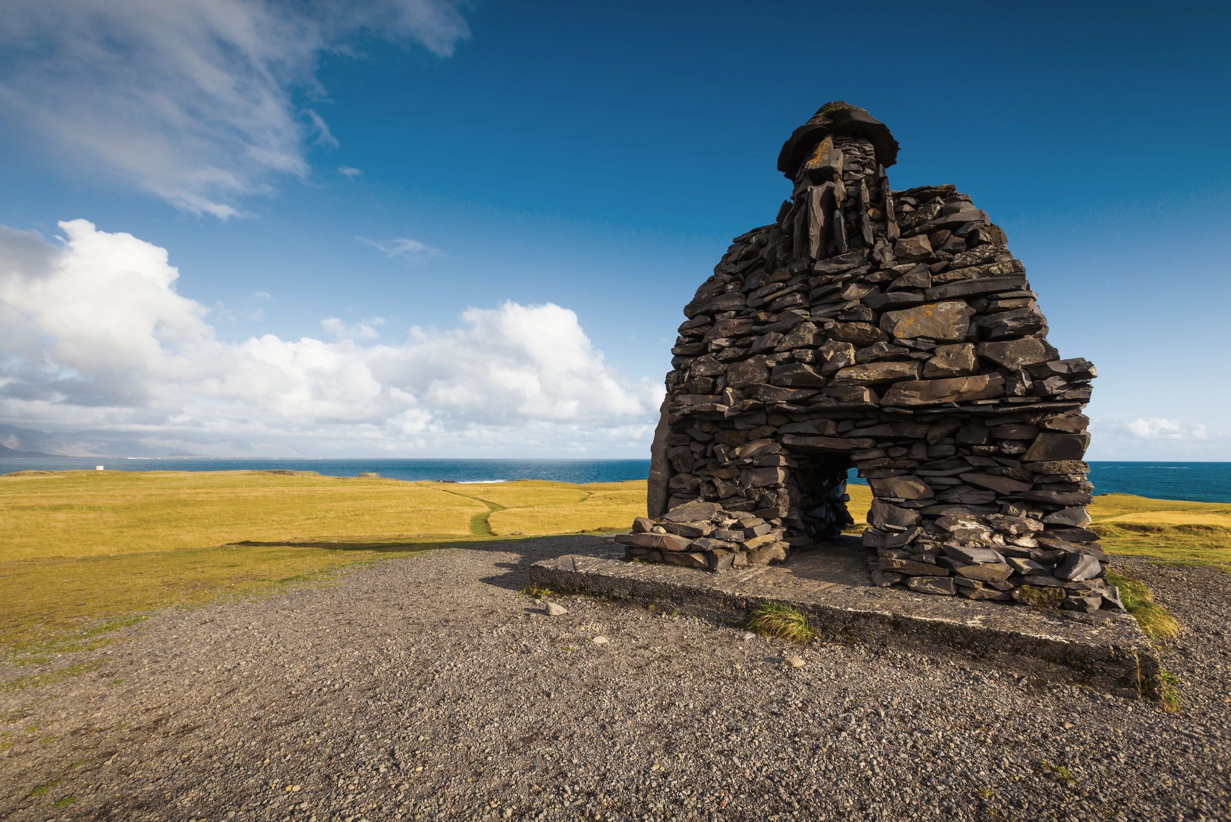
Arnarstapi (also referred to as Stapi) is a small fishing village with unique rock formations along the coastline, making it look like an artwork of nature, and the cliffs are filled with sea birds during the breeding season. Arnarstapi was a natural site for landings, making it ideal as a fishing port, so early on, it was a busy fishing and trading port. From 1565 through the 18th century, Danish agents had custodial power over Arnarstapi and commercial rights under the Kingdom of Denmark. A few old houses from the 18th century are still in Arnarstapi. During summers, the harbor is busy serving private fishing and recreational vessels and is a thriving destination for tourism. When coming to Arnarstapi, you will be greeted by a huge rock statue of Bárður Snæfellsás made by Ragnar Kjartansson. He is a half-man half-troll who was the first settler of Snæfellsnes who gave this peninsula its name. The story Bárðar Saga Snæfelssás tells of a terrible family tragedy related to Bárður and the settlers of Snæfellsnes. Helga was Bárður's oldest daughter of his 9 daughters, and one day she was playing with her cousins Rauðfeldur and Sölvi, sons of Bárður's half-brother Þorkell, by a beach when they pushed Helga onto an iceberg that drifted away to Greenland. Bárður got so angry he took the brothers under both arms and headed to the mountains, where he threw Rauðfeldur into the Rauðfeldsgjá gorge and Sölvi over the cliff Sölvahamar, killing both instantly. Hearing the news of his sons, Þorkell fought Bárður, who broke his leg and left him on the ground. Þorkell moved away, and Bárður took all his belongings and headed to the Snæfellsjökull glacier, where he is believed to have disappeared into the glacier. On the Snæfellsnes peninsula are a lot of locations bearing names in reference to Bárður Snæfellsás. After this tragedy, Bárður has been regarded as the guardian of the Snæfellsnes peninsula.
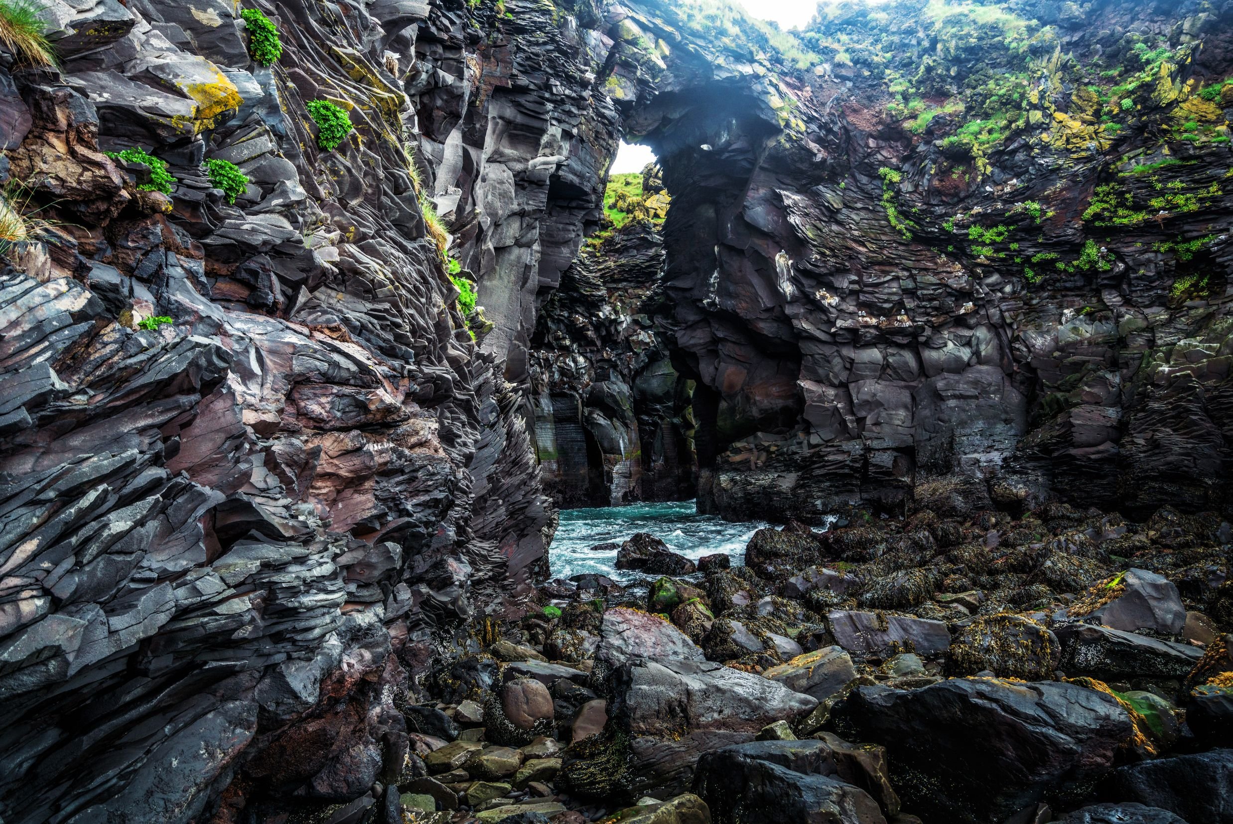
A walking trail runs from the statue of Bárður along the coastline, where you will see many of the amazing formations of aforementioned lava and basalt cliffs, vaults, and ravines eroded by waves for centuries. From the first observation platform, you will see basaltic caves beneath and a beautiful view over the Atlantic Ocean. Going onto the next platform gives you a great view of Gatklettur, a rock arch with a big hole extending from the basaltic cliffs. Walking further, you will reach the first of three ravines, which are like holes in the ground by the coastline. It's tempting to have a look down these ravines at the sea coming in, but please watch your steps and be careful so as not to fall into them. These ravines are collectively named Stapagjár (e. Ravines of Stapi), but individually, they are called Norðurgjá (e., The North Ravine), Miðgjá (e. The Middle Ravine), and Músagjá (e. The Ravine of Mice). On days when the weather is bad, and the waves are strong, you may see the surf splashing up into the air from these ravines. The stone bridges by these ravines attract people to walk over for great photo opportunities but keep in mind they could collapse at some point. Next to one of these ravines is Arnarstapaviti, a white square lighthouse 3 m (9.8 ft) tall. Standing next to the Snæfellsjökull glacier, hovering over Arnarstapi, is the peculiar 526 m (1,725 ft) high Stapafell, which is a palagonite volcano. From some angles, it looks like it's shaped like a pyramid.
-
The very small village of Búðir is a popular destination for visitors. Situated in Búðahraun (e. Lava Field of Búðir), it is believed to have been the landing of fishing and commercial ships since Iceland was settled, functioning mainly as the commercial and trading post of Snæfellsnes and the west coast region during the Danish trade monopoly. Búðahraun has been a protected area since 1977, originating from the eruption of Búðaklettur, a 88 m (289 ft) high scoria crater standing in the middle of the lava field, believed to have erupted 5,000-8,000 years ago. This pitch-black lava field is unique for the vegetation growing there, having 11 birch species of 16 in Iceland growing in the field. The eastern part of this lava field is pahoehoe lava which contains a lot of caves, fissures, and holes and some of them are visible while the others are covered in moss and vegetation. The sand on the shore by Búðir is almost exclusively composed of olivine grains, which is very rare, and since olivine is green the sand is somewhat green-yellowish in color. One of the most photographed churches of Iceland is the black wooden Búðakirkja (e. Church of Búðir), along with its graveyard. People from all over the world come to seal their love in this church, but like most churches in Iceland, it is not open to the public visiting due to more vandalism happening. But this is not the original church, but a replica built in 1987 of the former one which was built in 1848. The first church at Búðir was built in 1703 and churches have been rebuilt there several times since. Búðakirkja is the only reminder of the vibrant fishing village Búðir used to be until the 19th century. The first hotel in Búðir, called Hotel Búðir, was built in 1947, but unfortunately, it burned down to the ground in 2001. A new hotel was built shortly after in the same image as the older one and is a very beautiful and popular hotel to stay at.
On the way to Búðir, you will pass a farm called Öxl (e. Shoulder). It is the former home of the first AND only serial killer in Iceland, who lived in the 16th century; Björn Pétursson nicknamed Axlar-Björn. The most reliable documentation tells that Björn murdered 9 people with an axe, while various folklore says the number ranges from 14 to 19 people. His victims were mostly travelers passing by his farm, who Björn robbed and then killed, digging their bodies in the cowshed (while folklore tells he put their bodies into the pond Íglutjörn by his farm). Björn was arrested in 1596 after a traveler managed to escape and tell on him. Björn was found guilty and sentenced to death for his crimes at Laugarbrekkuþing (e. Assembly of Laugarbrekka). More bodies were discovered in the Búðarhraun lava field on Björn's land but he denied having killed them and claimed he had found them dead and kept their belongings. His execution was gruesome, like most of them were in those days in Iceland; his arms and legs were crushed with a sledgehammer while he was still alive, his head then cut off with an axe, and his body cut down for the body parts to be put up on poles. He was then buried in three separate graves marked with cairns of heaped-up stones in the land of Laugarholt by Hellnar to prevent him from returning as a ghost and haunting the living who were still afraid of him. Only one of these cairns still stands over one of his burial mounds, called Dreplakolludys, while the others were destroyed by road constructions and quarrying in the lava field. Dreplakolludys has now been declared as protected for its historical value.
-
Walking down a path is Ytri-Tunga, a beautiful golden sand beach most known for seal watching. Seals reside there all year, though you are not as likely to spot them during wintertime since the best time is in summer after they pup. The two species residing there are the harbor seal (lat. Phoca vitulina), also known as the common seal, and the grey seal (lat. Halichoerus grypus). The harbor seal is the more common seal specie in Iceland and they are genetically distinct from other harbor seals in the NE Atlantic Ocean. The grey seal is considerably larger than the harbor seal, with a longer flatter head.
Seals used to be vital to Icelanders for survival due to their meat, fat, and waterproof hides but hunting seals is now prohibited in Icelandic territory.
Please remember to not approach the seals and keep a distance of at least 50 m (164 ft) from them, both for you and the seals. They can become dangerous when frightened so keep any noise respectfully low.
Information.
-
Parking fees
Pickup & drop-off within the Reykjavik Capital Area
Private transport in an air-conditioned vehicle
Knowledgeable & experienced English-speaking driver-guide
-
Food & drinks (your private driver-guide can recommend stops for lunch and refreshments during the tour)
Extra bookable activities (can be added in the check-out process)
Entry or admission fees
Tip or gratuity
-
Please respect nature - do not throw out trash or walk on any moss.
For environmental responsibility purposes, you do not need to print out your e-ticket.
Your private driver-guide can always recommend different restaurants in the area and make stops on the way so you can purchase food/snacks/drinks, but you are also welcome to bring a packed lunch.
The total duration of this tour is dependent on whether extra bookable activities are added to the booking during checkout.
Road conditions or adverse weather could make some stops inaccessible during winter, so the itinerary may need to be altered if necessary.
Dress according to the weather by wearing warm and wind-/waterproof clothing in layers and bring gloves and a hat.
Wear suitable footwear, preferably waterproof with a good grip, in case of slippery conditions due to ice, rain, or gravel paths.
We may occasionally need to alter the tour itinerary due to unpredictable weather and road conditions in Iceland, especially during winter. The weather in Iceland can be quite unpredictable.
-
When booking this tour, you can choose from our standard tour (for shorter activities to add) or our extended tour (for longer activities to add). The following are the extra bookable activities available to add to your booking during the check-out process (please only add one activity to your booking):
Available to add to the standard tour:
Horseback riding by Snæfellsjökull (available only June 1 - Sep 15)
Kayak by Kirkjufell mountain (available only May 1 - Sep 30)
Vatnshellir Lava Cave tour (available all year)
Available to add to the extended tour:
Snowcat on Snæfellsjökull glacier (available only April 10 - Aug 31)